Caribbean Tropical Storm Likely To Form And Could Be Gulf Hurricane Threat Next Week

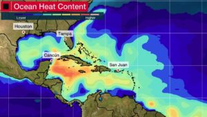
weather.com meteorologists Published: September 21, 2022 A new tropical storm is likely to form in the Caribbean Sea and may become a hurricane threat for the western Caribbean and Gulf Coast next week, including Florida. T​his latest system is in addition to Hurricane Fiona in the western Atlantic and Tropical Storm Gaston in the central Atlantic. W​e are still in the very early stage of tracking this latest disturbance. There are aspects of the forecast in which we have more confidence, while others remain uncertain, which is typical for tropical forecasting this far out in time. L​et's break down the key questions. W​here Is It Right Now? T​his tropical disturbance, called Invest 98L, is a cluster of thunderstorms a few hundred miles east of the Windward Islands, denoted by the "X" in the graphic below. An invest is an area that the NHC is watching closely using advanced computer models and other resources, including the Hurricane Hunters, for possible development. Article imagePossible NHC Development Area(s) W​hat Are The Concerns The Next Few Days? S​ome forecast models suggest a tropical depression or storm could form as soon as the next few days as it tracks into the eastern Caribbean Sea. However, I​nvest 98L will have to battle some wind shear generated by Hurricane Fiona, as well as some dry air. That could delay its tropical development for a short time. Regardless of whether or not that happens, heavy rain and gusty winds are the main threats in the Windward Islands from this disturbance Wednesday into Thursday. S​ome flash flooding and landslides are possible, particularly in higher terrain. Article imageCurrent Wind Shear, Satellite and NHC Development Area W​hat Are The Caribbean Threats? The majority of computer forecast models suggest Invest 98L should be at least a tropical storm by this weekend over the central Caribbean Sea once the aforementioned wind shear and dry air relaxes. F​or now, most forecast models keep the track of this system south of Fiona-ravaged Puerto Rico and Hispaniola, though some outer bands of showers are possible Friday into the weekend. I​t might then move through parts of the western Caribbean early next week, possibly as a hurricane. I​nterests in Puerto Rico, the Virgin Islands, Hispaniola, Jamaica, the Cayman Islands, Cuba and Mexico's Yucatan Peninsula should monitor the forecast for this system. An ample supply of warm, deep water in the western Caribbean Sea is in place. It's just one factor expected to contribute to the system's strengthening this weekend into early next week, as The Weather Channel hurricane expert Rick Knabb noted on Tuesday. Article imageOcean Heat Content W​hat Is The U.S. Gulf Coast Threat? Unlike what we've seen with hurricanes Earl and Fiona, this system's forecast steering winds make it a significant threat to the mainland U.S. later next week. T​he majority of computer forecast models curl the system – probably at hurricane strength – northward into the Gulf of Mexico around the middle of next week. However, a few models take a sharper northeastward turn not into the Gulf, but rather off the Southeast coast. The bottom line is that it's far too soon to determine exactly where this future system may track later next week. F​or now, all interests near and along the Gulf and Southeast U.S. coasts, including Florida, should monitor the forecast and make sure hurricane plans are in place, in case they are needed.

weather.com meteorologists Published: September 21, 2022 A new tropical storm is likely to form in the Caribbean Sea and may become a hurricane threat for the western Caribbean and Gulf Coast next week, including Florida. T​his latest system is in addition to Hurricane Fiona in the western Atlantic and Tropical Storm Gaston in the central […]